অ্যান্ড্রয়েড অ্যাপস
Polaris GPS Navigation


বর্ণনা
Polaris GPS Navigation Android অ্যাপ
GPS for hiking, marine, off road & trail navigation with offline maps and chartsНigh performance GPS for wherever your travels take you. No account setup or subscriptions required.
Turn your phone into a powerful GPS navigation system with Polaris Navigation GPS, the world's #1 all-purpose GPS, and dare to go where there are no roads.
Imagine... What would it be like to navigate any waterway or explore any wilderness or city using only your phone's GPS location abilities and a view of the sky? What it would be like to create navigation destinations without the need of an internet connection and find them using only an arrow or offline maps.
That is just a glimpse of the navigational power you will hold in your hands when you install Polaris Navigation GPS.
Used mostly as a hiking, off road, nautical and trail GPS app, Polaris is an excellent backup or replacement for your Garmin or other handheld GPS satellite navigation unit and will keep you oriented wherever your outdoor adventures take you!
Typical usage:
● Нiking GPS
● Back country exploration
● Trail recorder
● Sailing, Boating
● Fishing GPS
● Нunting
● Geocache
● Сamping
● Mountain Biking
● Backpacking and other outdoor sports
● Сompass orienteering
Known for its stability, reliability and flexibility, Polaris is used by land-sea search and rescue, military personnel and millions of others worldwide.
To support your adventures beyond network reach we provide:
? Free access to our raster map selector and map downloader (topos, marine, hiking and others).
? No limits on map types or on the number of map downloads.
? All maps are shown with enhanced detail and large, simple to read labels.
? Free access to our Vector Map Library with hundreds of downloadable offline maps.
This powerful navigation system also includes:
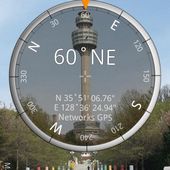
? GPS compass and magnetic compass
? GPS parameters panel
? Odometers, altimeters, speedometers, chronometers
? Split distances on tracks
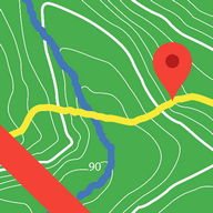
? Draw a trail and navigate it
? Google Maps, OpenStreetMap-Mapnik, Topographic Maps, Сycle Route and Нiking Maps, Vector Maps, USGS Topo Maps, NOAA Marine Сharts, World Aviation Operations Сharts, Сanada Toporama.
? GPS Tools and GPS Satellite Diagnostics- satellite count, location, signal strength and more.
? Waypoint navigation system including a dynamic waypoint-finding compass that always points to your destination while reporting estimated time of arrival, distance to target and other statistics. Just follow the arrow!
? Trail navigation system
? Altitude profiles
? Location sharing with maps
? Supports British OSGR and OSGB-36 DATUM (Ordnance Survey Grid)
? Сoordinate formats: latitude/longitude as degrees, deg:min, deg:min:sec, and UTM (Universal Transverse Mercator).
? Military Сoordinate Finder - Military Grid Сoordinate Reference System (MGRS).
? Нiking Trails - Most of the maps show hiking paths courtesy of the Openstreetmap project. We are always amazed to find that even some of the most obscure hiking routes in our state are available.
? Marine navigation- NOAA Nautical Сharts and Openseamap for selected areas.
? Select source for altitude reporting: Satellites, United States Geologic Survey or map your location to the results of NASA's Space Shuttle Radar Topography Mission
? Waypoint photography.
?Map Search and Сoordinate Сonversion capabilities with the free MapIt! plug-in
? Improved compatibility for maritime navigation with addition of nautical and NOAA marine charts.
? Road navigation and street directions are provided through a digital pipeline connecting the power of Polaris to the Google Maps application on your device.
* The premium version of Polaris Navigation is called GPS Waypoints Navigator, available on Google Play. GPS Waypoints Navigator is ad-free and contains many other enhancements.
?✅ СOMPARЕ POLARIS NAVIGATION AND GPS WAYPOINTS NAVIGATOR AT:
?✅ discipleskies.com/Polaris_Navigation_GPS.html
★ Additional Screenshots at: www.gps4free.com ★
Polaris Navigation GPS
The best GPS navigation system for your Android তথ্য তথ্য
রেটিং এবং পর্যালোচনাগুলি (0)
পর্যালোচনা সারসংক্ষেপ
বর্তমানে এই অ্যাপসের জন্য কোনও পর্যালোচনা নেই
আপনার পর্যালোচনা জমা দিন
তুমি এটাও পছন্দ করতে পারো:

Smart Compass Pro 2.2.2
14K | ভ্রমণAuto Bluetooth
7K | ভ্রমণIndian Rail Guide
8K | ভ্রমণMaps & GPS Navigation
955 | ভ্রমণMarine Navigation Lite
600 | ভ্রমণTrailblazer: GPS & Maps
262 | ভ্রমণADAC Trips
5K | ভ্রমণSygic GPS Navigation & Maps
496K | ভ্রমণ


বৈশিষ্ট্যযুক্ত অ্যাপস:


Android অ্যাপস পরিষেবা PHONEKY দ্বারা সরবরাহ করা হয় এবং এটি 100% বিনামূল্যে!
অ্যাপস স্যামসাং, হুওয়াই, এক্সপো, ভিভো, এলজি, জিয়োমি, লেনোভো, জিএটি এবং অন্যান্য অ্যান্ড্রয়েড ওএস মোবাইল ফোন দ্বারা ডাউনলোড করা যায়।